DJI Phantom 4 RTK UAV
Product Code: DJI-P4-RTK
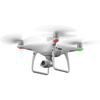
The Phantom 4 is DJI�s most compact and accurate low altitude mapping solution offering centimetre-accurate data while requiring fewer ground points.A new RTK module is integrated directly into the Phantom 4RTK, providing real-time, centimetre-level positioning data for improved absolute accuracy on image metadata. Sitting just beneath the RTK receiver is a redundant GNSS module, installed to maintain flight stability in signal-poor regions such as dense cites. Combining both modules, the Phantom 4RTK is able to optimise flight safety while ensuring the most precise data is captured for complex surveying, mapping and inspection workflows.
Fit the Phantom 4 RTK to any workflow, with the ability to connect this positioning system to the D-RTK 2 Mobile Station, NTRIP (Network Transport of RTCM via Internet Protocol) using a 4G dongle or WiFi hotspot, to store the satellite observation data to be used for Post Processed Kinematics (PPK).
To take full advantage of the Phantom 4RTK�s positioning modules, the new TimeSync system was created to continually align the flight controller, camera and RTK module. Additionally, TimeSync ensures each photo uses the most accurate metadata and fixes the positioning data to the centre of the CMOS � optimising the results from photogrammetric methods and letting the image achieve centimetre-level positioning data.
To legally fly a small unmanned aerial system in the UK the Operator is legally required to hold a Permission for Commercial Operations (PfCO) from the UK Civil Aviation Authority (CAA). Before a PfCO is issued the Operator must write and have approved an Operations Manual. Also any pilots who are to fly for that Operator must hold a CAA approved NQE issued qualification demonstrating their operating competence and flying capability.
Visit the Sunbelt Rentals website for more information on DJI Phantom 4 RTK UAV
ENQUIRY FORM