Leica Pegasus Two Ultimate Mobile Mapping System
Product Code: 868744
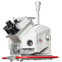
Leica Pegasus:Two UltimateA complete mobile mapping solution incorporating two back-to-back cameras creating a 24-megapixel 360-degree image that can be calibrated in the LiDAR profiler data, enabling digital reality captures from car, train or boat to enable fast processing at the office.
The Leica Pegasus: Two Ultimate captures data in a variety of lighting conditions and vehicle speeds � a high dynamic range is enabled by a large sensor-to-pixel ratio and a dual-light sensor. Photogrammetry and image quality is improved with the increased side camera resolution of 12-megapixels and onboard JPEG compression.
Data can be saved directly onto the removable drive and connected seamlessly to any PC or server with a USB 3.0 interface.
Seamless imagery with 360� camera
360� 24-megapixel camera system providing stitch-free images
Telescopic pole - enables easy storage to prevent damage
Point cloud colourised by 360� camera
Point cloud and 360� image can be viewed together as an overlay
Increased flexibility with easier data transfer
Additional sync ports to connect thermal imaging, multibeam sonar and ground penetrating radar sensor
Additional camera ports for pavement cameras or additional side cameras engaging target image capture on road signs or tunnel walls
Removable solid-state Hard Disk with integrated USB 3.0 connection
Data sharing independently from web browser
Access and share the data at anytime from anywhere from the cloud to enable faster visualisation, data delivery and project invoicing.
Visualisation of captured data
Complete storage in the cloud
Point cloud rendering in any browser without the need for a plug-in
Images are calibrated to the point cloud and can be used to navigate and measure
Higher image quality with new side cameras
Thanks to the geometry of the possible stereo pairs, the upgraded systems require less cameras, but offers significant image quality improvement.
Side cameras deliver 8.0 FPS at 12-megapixels at 61� x 47� FOV
The maximum pixel size at 10m is 3mm
Adjustable pavement camera with 12mm lens, enables targeted image capture along a road or in a tunnel
Mobile Mapping can be used in a vast range of applications, such as:
Topographical surveys for large road projects
White line surveys
Town or city street mapping and modelling
Railway surveys
Airport runway and taxiway surveys
Quarry mapping
Beach and cliff erosion mapping and monitoring
Asset and GIS data collection
Advantages of using a Mobile Mapping solution:
Quickly capture a comprehensive dataset that can be used for multiple purposes
Reduced delivery time with ability to create higher-value deliverables
Ability to move decision making into the office
Vehicle mounted survey grade accuracies
Increased safety
Visit the Sunbelt Rentals website for more information on Leica Pegasus Two Ultimate Mobile Mapping System
ENQUIRY FORM