Pix4Dmapper Pro
Product Code: PIX4D-PRO-1MR
Desktop software for professional drone-based mapping.Pix4Dmapper software automatically converts images taken by hand, by drone, or by plane, and delivers highly precise, georeferenced 2D maps and 3D models. They�re customizable, timely, and complement a wide range of applications and software.
Full Automatic Workflow: One click to results.
Compatible with any camera: Now compatible with video files.
rayCloud Editor: A novel way to assess quality, refine projects, and measure features.
Mosaic Editor: The easiest tool to produce perfect orthomosaics.
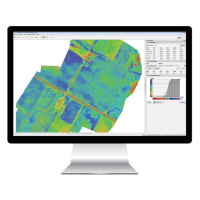
Index Calculator: Photogrammetry meets precision agriculture.
Key Outputs:
3D Point Cloud
Laser scanner quality 3D points from a consumer-grade camera. Clean from moving objects, aerial perspective with limited occlusions, and low acquisition time.
True Orthomosaic
High resolution aerial map with corrected perspective, putting you in control of geographic data generation.
3D Textured Model
Full 3D triangle mesh with photorealistic texturing, perfect for sharing and online visualization.
Digital Surface Model
Accurate, georeferenced elevation map, ready for your preferred GIS workflow.
NDVI Map
Vegetation index map from multispectral cameras provides vital information on plant health for faster decision making, optimized management and better yields.
Visit the Sunbelt Rentals website for more information on Pix4Dmapper Pro
ENQUIRY FORM