3D Laser Scanning Surveys
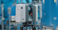
3D Laser Scanning SurveysWe specialise in 3D laser scanning which is high-definition surveying; a method of collecting high-density spatial data sets in a fraction of the time taken by traditional systems. The scanner emits a laser horizontally and vertically, rotating through 360°. The reflections are detected; as many as 100,000 are possible per second due to internal mirrors and rotation, so this surveying technique is capable of unparalleled precision and detail. As well as collecting the standard data usually targeted during a survey, the intensity of the reflected light and the distance of the objects are evident in the point cloud data set.
Our highly skilled surveyors use the millions of surveyed points to produce 2D drawings, 3D models or simple jpeg images as requested by the client. A laser scanning survey can be viewed as a fly-through of a 3D CAD model, viewed panoramically from different perspectives, with zooming for detail and overlaying of photography to give you a very real and usable visualisation of your project. The range of uses for 3D laser scanning surveys is extensive; data can be interfaced with other CAD platforms to allow as-built and new design data to be integrated for clash and coordination checks, being accurately positioned using OS data, National Grid and GPS coordinates.
Using 3D laser scanning can save you time and money; a single surveyor can collect millions of extremely accurate data points in a short time, making this an efficient technique. SJ Geomatics uses state-of-the-art technology to bring you exceptional quality that gives high definition to structures and features within your project survey.
For more information on 3D Laser Scanning Surveys , call us on 01986 872716 or email us at web@sjgeomatics.co.uk and one of our expert team will be happy to get your project underway.

Visit the SJ Geomatics Ltd website for more information on 3D Laser Scanning Surveys
ENQUIRY FORM